PRIM POINT LIGHTHOUSE
Owned by the Municipality of the District of Digby
For visitor information, visit Friends of Point Prim on Facebook.
View No Ka Oi Drone Video - Prim Point Lighthouse
ACKNOWLEDGEMENT:
"Sailing Directions, Nova Scotia (Atlantic Coast) and Bay of Fundy," First Edition, 1990, Dept of Fisheries and Oceans, Ottawa, Canada
Location
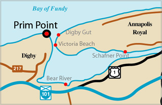 Digby Gut. - Point Prim (Prim Point), a rocky headland, is the west entrance point for Digby Gut, the deep water passage, 0.4 mile wide, between high steep shores, which leads to Annapolis Basin. Lights. - Point Prim light is shown from a white tower, with red vertical stripes, on the corner of a square building situated on the point (44.41 N, 65.47 W).
Digby Gut light is shown from a skeleton tower, 24 feet (7.3 m) high, adjacent to a white building situated on the east side of the entrance to Digby Gut (44.41 N, 65.46 W).
Fog signals. - A signal of one blast every 30 seconds is sounded from the Point Prim light building; the horn points 318 deg.
A signal of one blast every 15 seconds is sounded from the Digby Gut light building; the horn points 337deg.
PRIM POINT I - Light Details
- Location: West point of entrance to Annapolis Basin
- Standing: This light is no longer standing.
- Operating: This light is no longer operating.
- Date Automated: Automated by 1987
- Began: 1817
- Year Lit: 1817
- Structure Type: Pentagonal tower, vertical stripes, dwelling attached
- Light Characteristic: Fixed White (1857)
History Items for This Lighthouse
- 1817 - reports of an earlier light, destroyed by fire in 1817
- 1800's - known as The Fundy Light
- 1857 - fountain lamp, 5 burners, 2 catatropic lenses
- 1871 - fog signal established - 1873 - Mar 16 - lighthouse destroyed by fire
PRIM POINT II - Light Details
- Location: West point of entrance to Annapolis Basin
- Standing: This light is no longer standing.
- Operating: This light is no longer operating.
- Began: c. 1875
- Year Lit: c. 1875
- Structure Type: Square wood tower, white, red stripes, dwelling attached
- Light Characteristic: Flashing White (1941)
- Tower Height: 022ft feet high.
- Light Height: 076ft feet above water level.
History Items for This Lighthouse
- 187x - built on same site as original tower - 1871 - fog signal established
- 1876 - struck by lightning, no damage - 1883 - fixed white, catatropic lens, 13m
- 1922-1941 - catatropic long focus lens, flashing white (7s), diaphone fog signal
- 1964 - tower and dwelling demolished, pushed over cliff
PRIM POINT III - Light Details
- Location: West point of entrance to Annapolis Basin
- Standing: This light is still standing.
- Operating: This light is operational
- Automated: All operating lights in Nova Scotia are automated.
- Date Automated: Automated by 1993
- Began: 1964
- Year Lit: 1964
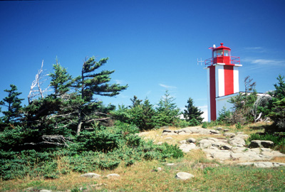
- Structure Type: Square concrete tower, white, red stripes, attached to bldg
- Light Characteristic: Isophased White (1992)
- Tower Height: 025ft feet high.
- Light Height: 080ft feet above water level.
History Items for This Lighthouse
- 1964 - built further back from cliff than original towers
- 1976 - assistant keeper drowned tending lobster traps
- 1992 - 4th order dioptric lens, electric lantern, fog signal
Lightkeepers for Prim Point Lighthouse
Bray, Frederick XXXX1857XX
Highlights
- County: Digby
- Region: Fundy Shore & Annapolis Valley
- Body of Water: Bay of Fundy
- Scenic Drive: Evangeline Trail
- Site Access: By Car
- Characteristic: Isophased White (1992)
- Tower Height: 025 ft
- Height Above Water: 080 ft
- Latitude: 44~41~28.0
- Longitude: 65~47~10.8
- Off Shore: No
- Still Standing: Yes
- Still Operating: No