 Kidston Island Lighthouse
Owned by the Village of Baddeck
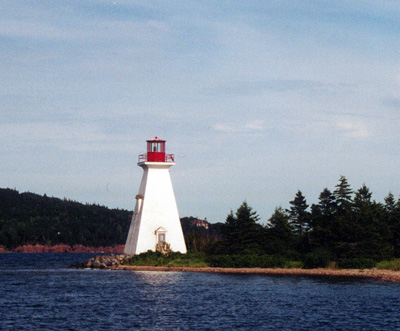
Lights are situated on both ends of Kidston Island. The NE light is a white square towerat an elevation of 14.6m (48ft); the SW light, at an elevation of 11.5m (38ft) is a white circular tower with red bands.
ACKNOWLEDGEMENT: "Sailing Directions, Nova Scotia (Atlantic Coast) and Bay of Fundy," First Edition, 1990, Dept of Fisheries and Oceans, Ottawa, Canada
Photo - © Kathy Brown, Kidston Island Lighthouse, 2002
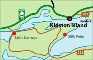
Kidston Island Lighthouse Locator Map
KIDSTON ISLAND - Light Details
- Location: Northeast point of island, entrance to Baddeck
- Standing: This light is still standing.
- Operating: This light is operational
- Automated: All operating lights in Nova Scotia are automated.
- Date Automated: Automated by 1960
- Began: 1875
- Year Lit: 1875
- Structure Type: Square wood tower, white, octagonal red lantern
- Light Characteristic: Fixed Red (1922)
- Tower Height: 050ft feet high.
- Light Height: 048ft feet above water level.
History Items for This Lighthouse
- 1908 - alteration of some form
- 1922 - 4th order dioptric lens
- 1930 - listed at 50ft, fog horn in answer to vessels
- 1941 - in operation
Highlights
- County: Victoria
- Region: Cape Breton Island
- Body of Water: Baddeck Harbour
- Scenic Drive: Bras d'Or Lakes Scenic Drive
- Site Access: By Boat
- Characteristic: Fixed Red (1922)
- Tower Height: 050 ft
- Height Above Water: 048 ft
- Latitude: 46~05~53.3
- Longitude: 60~44~31.3
- Off Shore: Yes
- Still Standing: Yes
- Still Operating: No