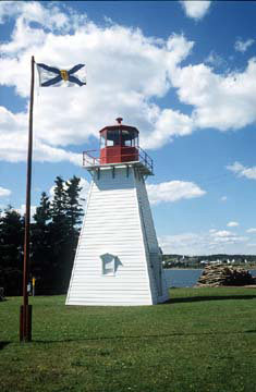
Jerome Point Lighthouse
Owned by the Government of Canada
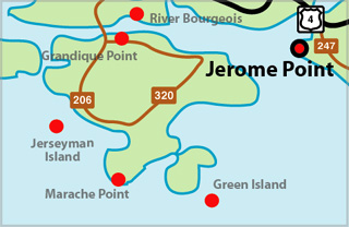
Jerome Point Lighthouse Locator Map
JEROME POINT I - Light Details
- Location: Near entrance to St. Peter's Canal
- Standing: This light is no longer standing.
- Operating: This light is no longer operating.
- Began: 1883
- Year Lit: 1883
- Structure Type: Tapered square wood tower, white, dwelling attached
- Light Characteristic: Fixed Red (1922)
- Tower Height: 036ft feet high.
- Light Height: 054ft feet above water level.
History Items for This Lighthouse
- 1922 - 7th order dioptric lens, hand fog horn
- 1930 - fog signal in answer to vessels
JEROME POINT II - Light Details
- Location: Near entrance to St. Peter's Canal
- Standing: This light is still standing.
- Operating: This light is operational
- Automated: All operating lights in Nova Scotia are automated.
- Date Automated: Automated by 1960
- Began: 1956
- Year Lit: 1956
- Structure Type: Tapered square wood tower, white, red lantern
Highlights
- County: Richmond
- Region: Cape Breton Island
- Body of Water: St. Peter's Bay
- Scenic Drive: Fleur-de-lis Trail
- Site Access: By Car
- Characteristic:
- Tower Height:
- Height Above Water:
- Latitude: 45~38~53.9
- Longitude: 60~52~21.8
- Off Shore: No
- Still Standing: Yes
- Still Operating: No