Enragee Point Lighthouse
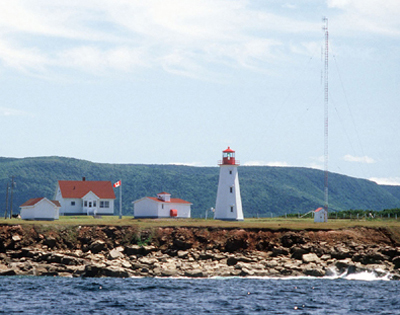 The light is a white octagonal concrete tower with a red upper portion, 42 feet (13m) high.
ACKNOWLEDGEMENT: Contributor: Kathy Brown.
Sources: List of Lights 1989, NSLPS database, Sailing Directions, Gulf and River St. Lawrence, 1985.
Photo - © Courtesy Department of Fisheries and Oceans, Enragee Point Light Station c. 1985
History
The original tower was constructed in 1937. The concrete tower replaced it at some time between 1955 and 1962.
The lighthouse was automated in 1988.
Enragee Point Lighthouse Locator Map
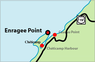 The town of Cheticamp is on the west side of Cape Breton Island. The light stands on the northwest point of Cheticamp Island. The island is joined to Cape Breton Island by a narrow beach of sand and shingle at the south end. The coast of Cheticamp Island is a high cliff which is constantly being undermined by the sea.
ENRAGEE POINT I - Light Details
- Location: On northwest point of Cheticamp Island
- Standing: This light is no longer standing.
- Operating: This light is no longer operating.
- Began: 1937
- Year Lit: 1937
- Structure Type: Lantern, red, on roof of square wood dwelling, white
- Light Characteristic: Occulting White (1943)
- Tower Height: 040ft feet high.
- Light Height: 055ft feet above water level.
History Items for This Lighthouse
- 1941 - acetylene fog gun (fired once per minute)
- 1941 - 1943 - 4th order dioptric lens, occulting white (15s)
- 1955 - 1962 - replaced by present tower
ENRAGEE POINT II - Light Details
- Location: On northwest point of Cheticamp Island
- Standing: This light is still standing.
- Operating: This light is operational
- Automated: All operating lights in Nova Scotia are automated.
- Date Automated: Automated by 1988
- Began: c. 1955
- Year Lit: c. 1955
- Structure Type: Octagonal concrete tower, white, red lantern
- Light Characteristic: Flashing White (1992)
- Tower Height: 042ft feet high.
- Light Height: 073ft feet above water level.
History Items for This Lighthouse
- 1955 - 1962 - replaced original tower of 1937
- 1990 - alteration of some form
- 1992 - electric lantern, mercury vapour, group flashing white (24s), fog signal
Highlights
- County: Inverness
- Region: Cape Breton Island
- Body of Water: Cheticamp Harbour
- Scenic Drive: Cabot Trail
- Site Access: By Car
- Characteristic: Flashing White (1992)
- Tower Height: 042 ft
- Height Above Water: 073 ft
- Latitude: 46~38~58.4
- Longitude: 61~01~35.2
- Off Shore: No
- Still Standing: Yes
- Still Operating: No