 Devils Island South East Lighthouse
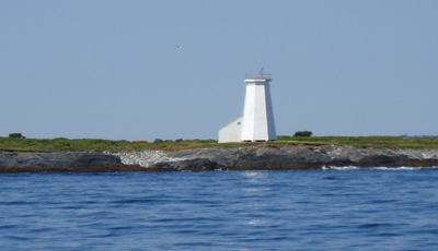
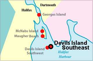
Devils Island (44.35N 63.28W), 4.6m (15ft) high, treeless, but with a number of derelict dwellings is at the NE entrance to Halifax Harbour.
Devils Island light is shown from a white octagonal tower on the island.
ACKNOWLEDGEMENT: "Sailing Directions, Nova Scotia (Atlantic Coast) and Bay of Fundy," First Edition, 1990, Dept of Fisheries and Oceans, Ottawa, Canada
Photo - © Kathy Brown, Devils Island South East Lighthouse in 2004
Devil's Island South East Lighthouse Locator Map
DEVILS ISLAND SOUTHEAST - First Light
- Location: Southeast end of island, mouth of Eastern Passage
- Standing: This light is still standing.
- Operating: This light is operational
- Automated: All operating lights in Nova Scotia are automated.
- Date Automated: Automated by 1967
- Began: 1877
- Year Lit: 1877
- Structure Type: Tapered octagonal wood tower, white
- Light Characteristic: Flashing White (1992)
- Tower Height: 039ft feet high.
- Light Height: 052ft feet above water level.
History Items for This Lighthouse
- 1877 - established 524ft from original tower, fixed red - 1922 - 4th order diop
- 1885 - 1940 - lifeboat stationed on the island - 1941 - tower then 45ft, 52ft
- 1949 - original tower discontinued, light to group flashing red
- 1959 - light changed again to group flashing white
DEVILS ISLAND SOUTHWEST - Last Light
- Location: Southwest end of island, mouth of Eastern Passage
- Standing: This light is no longer standing.
- Operating: This light is no longer operating.
- Began: 1852
- Year Lit: 1852
- Structure Type: Octagonal wood tower, white
Lightkeepers for Devils Island South East Lighthouse
- Bowen, Edward 1852-1861
- Horn, Edward 18XX-18XX
- Fulker, B. 1863-1886
- Fulker, W.G. 1886-1918
- Faulkner, W.J. 1918-1936
- Faulkner, K.A. 1936-1942/1944-1949
- Faulkner, E.S. 1942-1944
- Henneberry, B.A. 1949-1953
- Henneberry, L.V. 1953-1954
- Messenger, B.C. 1954
- MacDonald, C.C. 1954-1967
Highlights
- County: HRM
- Region: Halifax Metro
- Body of Water: Eastern Passage
- Scenic Drive: Halifax / Dartmouth
- Site Access: By Boat
- Characteristic:
- Tower Height:
- Height Above Water:
- Latitude: 44~34~51.7
- Longitude: 63~27~28.1
- Off Shore: Yes
- Still Standing: No
- Still Operating: No