 Cross Island Lighthouse
Cross Island, 90 feet (27m) high and wooded, divides the approach to Lunenburg Bay into two channels, of which the north one is encumbered with shoals and intricate, and the south channel wide and clear of dangers.
Cross Island light is shown from a white pyramidal tower, 38 feet (11.7m) high on the east point of the island (44.19N 64.10W). A fog signal of two blasts every minute is sounded from a horn close to the light; the horn points 164deg.
ACKNOWLEDGEMENT: "Sailing Directions, Nova Scotia (Atlantic Coast) and Bay of Fundy," First Edition, 1990, Dept of Fisheries and Oceans, Ottawa, Canada
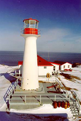
Photo - © Chirs Mills, Cross Island Lighthouse, Fiberglass Tower, after 1980
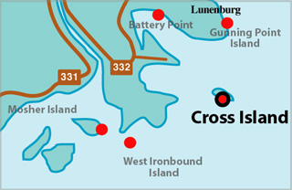
Cross Island Lighthouse Locator Map
CROSS ISLAND I - Light Details
- Location: East point of island
- Standing: This light is no longer standing.
- Operating: This light is no longer operating.
- Began: 1834
- Year Lit: 1839
- Engineer: Rudolf & Heckman
- Structure Type: Octagonal wood tower, red, red lantern
- Light Characteristic: Occulting White (1941)
- Tower Height: 058ft feet high.
- Light Height: 100ft feet above water level.
History Items for This Lighthouse
- 1832- tower completed, not lit, white, large black cross - 1834 - painted red
- 1883 - listed as Malaquash Bay, catatatropic lens, occulting white, 52ft, 90ft
- 1922 - 1941 - 4th order dioptric lens, group occulting white (30s), air diaphone
- 1960 - tower, some buildings burnt, fire started in oil furnace
CROSS ISLAND II - Light Details
- Location: East point of island
- Standing: This light is no longer standing.
- Operating: This light is no longer operating.
- Began: 1960
- Year Lit: 1960
- Structure Type: Aluminum framework tower, fluorescent orange
- Tower Height: 067ft feet high.
- Light Height: 078ft feet above water level.
History Items for This Lighthouse
- 1960 - replaced original tower of 1839 which burnt
1962 - 1965 - reflected in Sailing Directions as between these dates
1966 - fog signal, radiobeacon in operation
1980 - replaced by present tower
CROSS ISLAND III - Light Details
- Location: East point of island
- Standing: This light is still standing.
- Operating: This light is operational
- Automated: All operating lights in Nova Scotia are automated.
- Date Automated: Automated by 1989
- Began: 1980
- Year Lit: 1980
- Structure Type: Circular fibreglass tower, white, red lantern
- Light Characteristic: Flashing White (1992)
- Tower Height: 038ft feet high.
- Light Height: 082ft feet above water level.
History Items for This Lighthouse
- 1980 - replaced second tower of 1960
- 1992 - electric lantern, flashing white (10s), fog signal
Lightkeepers for Cross Island Lighthouse
- Locke, Ethel XXXX
- Mills, Chris 19XX-19XX
Highlights
- County: Lunenburg
- Region: South Shore
- Body of Water: Lunenburg Bay
- Scenic Drive: Lighthouse Route
- Site Access: By Boat
- Characteristic: Flashing White (1992)
- Tower Height: 038 ft
- Height Above Water: 082 ft
- Latitude: 44~18~43.7
- Longitude: 64~10~06.4
- Off Shore: Yes
- Still Standing: Yes
- Still Operating: No