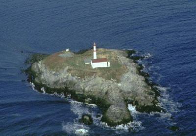
 Carter Island Lighthouse
ACKNOWLEDGEMENT: Sailing Directions, Nova Scotia (Atlantic Coast) and Bay of Fundy, First Edition, 1990, Dept of Fisheries and Oceans, Ottawa, Canada
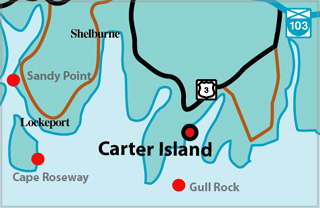
Carter Island Lighthouse (Lockeport) Locator Map
 Carter Island is situated about 0.4 mile north of Cranberry Island in the approach to Lockeport Inner Harbour. A light is shown at an elevation of 49 feet (15 m) from a white circular tower 30 feet (9.1 m) high, with two red bands, on Carter Island.
CARTER ISLAND I (LOCKEPORT) - Light Details
- Location: South end of island, inner entrance to Lockeport
- Standing: This light is no longer standing.
- Operating: This light is no longer operating.
- Began: 1872
- Year Lit: 1872
- Structure Type: Square wood tower, white
- Light Characteristic: Fixed Red (1922)
- Tower Height: 029ft feet high.
- Light Height: 066ft feet above water level.
History Items for This Lighthouse
- 1883 - catatropic lens, fixed red, 9m - 1918 - fog signal established
- 1922 - 7th order dioptric lens, hand fog horn
- 1930 - replaced by second tower
CARTER ISLAND II (LOCKEPORT - Light Details
- Location: South end of island, inner entrance to Lockeport
- Standing: This light is no longer standing.
- Operating: This light is no longer operating.
- Began: 1930
- Year Lit: 1930
- Structure Type: Square wood lantern, white, on roof of dwelling, white
- Light Characteristic: Fixed Red (1964)
- Tower Height: 038ft feet high.
- Light Height: 052ft feet above water level.
History Items for This Lighthouse
- 1930 - replaced original tower of 1872
- 1941 - 5th order dioptric lens, fixed red, 8m, hand fog horn
- 1964 - 5th order drum lens, kerosene - 1973 - still manned at this time
- 1989 - replaced by present fibreglass light
CARTER ISLAND III (LOCKEPORT - Light Details
- Location: South end of island, inner entrance to Lockeport
- Standing: This light is no longer standing.
- Operating: This light is no longer operating.
- Date Automated: Automated by 1993
- Began: 1989
- Year Lit: 1989
- Structure Type: Fiberglass, no lantern
Highlights
- County: Shelburne
- Region: South Shore
- Body of Water: Lockeport Harbour
- Scenic Drive: Lighthouse Route
- Site Access: By Boat
- Characteristic:
- Tower Height:
- Height Above Water:
- Latitude: 43~42~19.3
- Longitude: 65~06~04
- Off Shore: Yes
- Still Standing: No
- Still Operating: No