Cape Roseway Lighthouse
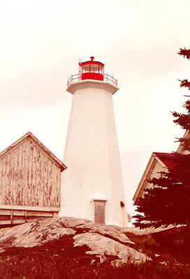 The current lighthouse is an octagonal concrete building with a red lantern.
ACKNOWLEDGEMENT: Contributors: Chris Mills, Kathy Brown, Bernice
Goodick
Sources: Informal Building Report 87-127, Federal Heritage Buildings Review
Office (FHBRO), April 11th, 1988, "Atlantic Sentinel" The Standard, Jan.
1950, pp 12 - 15, courtesy Bernice Goodick, and a letter from Bernice.
Photo - © Hubert Hall, Cape Roseway Lighthouse c. 1998
Early History
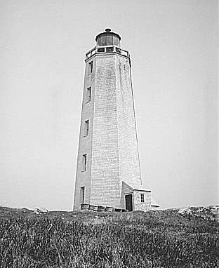 Cape Roseway on McNutt's Island, N.S. is the site of an early-established
light (1788) marking the entrance to Shelburne Harbour. The first lighthouse
built at Cape Roseway in 1788 was preceded in Canada by only two others - one
at Louisbourg (1733) and another at Sambro island (1758) near Halifax. Like
them, the 92-foot octagonal Cape Roseway lighthouse was built with locally cut
stone in "the old world style"
Cape Roseway on McNutt's Island, N.S. is the site of an early-established
light (1788) marking the entrance to Shelburne Harbour. The first lighthouse
built at Cape Roseway in 1788 was preceded in Canada by only two others - one
at Louisbourg (1733) and another at Sambro island (1758) near Halifax. Like
them, the 92-foot octagonal Cape Roseway lighthouse was built with locally cut
stone in "the old world style"
The settlement of Shelburne was the reason a light was established here. In
the inner reaches of an excellent and sizable harbour rivaling the one at
Halifax, the town in 1783 had quickly (but only briefly) become the largest
urban centre in British North America.
It had been regarded as a potential place for British development as early as 1720 and was especially considered after the expulsion of the Acadians from the area in 1755. Some English-speakers from the pre-revolutionary colonies to the south did move in during the 1760s and 1670s under the leadership of speculator/entrepreneur, Alexander McNutt, but it was not until 1783 that the town began to flourish. In that year, about 16,000 United Empire Loyalists landed here and built thousands of houses and commercial establishments.
Governor Wentworth in Halifax considered Shelburne Harbour of great consequence to the safety and supply of Halifax and a safe retreat in the hurricane months for the fleets employed in the West Indies. He also saw it as peculiarly well-adapted for all naval operations necessary for defense of or offense on the east coast of America.
Discontinuance of government assistance a few years later took away much of the loyalists' incentive to stay, and most moved on to the Annapolis Valley, Halifax, or the St. John area of New Brunswick. Properties in Shelburne were abandoned, leaving a near-ghost town by 1818 at which time only 300 souls remained.
Although Shelburne quickly dropped in population and importance from its initial status, it did carry on as a small port specializing in the building of schooners and brigantines. When steel-hulled steam-powered ships began to replace wooden sailing vessels late in the 19th century, production shifted to more industrialized cities, particularly those in England and Shelburne's economy fell back on fishing.
As well as having a number of military reserves set aside for an extensive Navy - planned but not realized for this location, Governor Wentworth ordered the construction of the Cape Roseway lighthouse. He boasted that it was the finest on the continent -and that a British military officer had rated it equal to any in the English Channel. A similar one was built in Shelburne itself in 1789.
From its lighting in 1788 and up to the recent past, the Cape Roseway lighthouse guided the comings and goings of the newly-built wooden sailing ships, the fishing vessels, and other assorted marine traffic in the area. Unfortunately, the stone tower was struck by lightning in 1959 and the ensuing fire destroyed its heavy oak timbers giving support inside.
Exterior wooden clapboards (in place by 1835 at least), had formed a protective sheath around the stone but were destroyed as well. Intense heat caused large cracks in the shell-based mortar, and some of the granite blocks were dislodged. Concluding that the tower was beyond economical repair, the Canadian Coast Guard had it demolished to make way for the new and present one on the same site - a 48-foot octagonal concrete tower of standard plan.
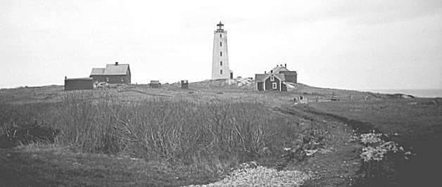
A number of other building additions and changes have been effected at Cape Roseway throughout its long history. Currently, there are three houses on site. According to Coast Guard files, one was built in 1958, and the other two apparently pre-date it by a few years at least.
Other buildings include a barn (1880), a frame building to shelter the steam fog trumpet later transformed into a storehouse, and a new fog alarm building (1916-17). When the old lighthouse was being demolished following its fire, a temporary light was set on the roof of this latter building (1960).
ACKNOWLEDGEMENT: Contributors: Chris Mills, Kathy Brown, Bernice
Goodick
Sources: Informal Building Report 87-127, Federal Heritage Buildings Review
Office (FHBRO), April 11th, 1988, "Atlantic Sentinel" The Standard, Jan.
1950, pp 12 - 15, courtesy Bernice Goodick, and a letter from Bernice.
Later History
 Cape Roseway Lightstation in the 1950's
In 1950, an article in The Standard (a weekend newspaper supplement) noted
that every 10 seconds, Cape Roseway Lighthouse sent out a 100,000 candlepower
warning beam that could be seen for 18 miles on clear nights. The kerosene
fueled lamps were housed in a Fresnel lens weighing 2 tons. When visibility
was low, the diesel powered fog horn emitted two dismal three-second groans a
minute. The light and fog horn were tended by 62 year old Otis Orchard and his
assistant Nelson Goulden. Orchard lived with his wife on the island. Goulden's
family lived on the mainland in Gunnings Cove. The two men worked six hour
shifts and shared the maintenance work.
The lighthouse had "Six-foot walls of cut stone, strong iron doors with iron
gudgeons, gun embrasures and heavy oak and hackmatack timbering recalling the
days when pirates made the lighthouse their special target." (This was the
stone lighthouse that burned in 1959.)
In his spare time Otis Orchard did oil paintings of ships. He and his wife raised cabbages, potatoes, carrots and turnips in their vegetable garden. Nelson Goulden made needlepoint cushion covers and bicycled around the three-mile-long island.
Sometimes some of the 30 residents of McNutts Island would pay a visit. They were decendants of loyalist Scottish and Irish settlers who came to the island in 1764 after the American Revolution.
Otis Orchard recalled four shipwrecks on the island during his past 20 years as keeper, the Nellie Viola, the Governor Marshall, a government examination boat, and the two-masted sailing vessel Good Luck. The Good Luck sank in five minutes after running aground on the night of Jan. 2, 1937. Orchard recalled that "The captain and his crew were lucky. They rode ashore on the Good Luck's cargo of laths. Otherwise they would have drowned. There was a big blizzard that night and we didn't know about the wreck until the men came to the door and asked for shelter. During Orchard's time, crew members of all the ships that were wrecked survived.
The article in The Standard concludes: "Lightkeepers like Orchard, who will retire in three years . . . are a hardy breed. They have answered this calling as far back as 300 BC. . . There is as yet no indication that improved navigation aids such as radar and direction finders will put them out of business."
Bernice Goodick's father succeeded Otis Orchard as Keeper on Cape Roseway. She and her mother moved to McNutts Island, to the lightstation, the summer of 1953. Her father was the Assistant Lightkeeper to Mr. Otis Orchard for a few months. When Otis Orchard retired, her father became Lightkeeper until June 1956.
They had no electricity or any luxuries. They had to carry 5 gal. cans of kerosene up, she thinks, 9 sets of stairs and pump the pressure up on the light every four hours; six at night. Cape Negro would light first, then Cape Roseway, then Gull Rock.
Her father had an Assistant Lightkeeper, Aubrey Hipson. When the Orchards retired, Bernice and her family moved into the new house which had a bathroom and floor furnace; still no lights or power, but what a luxury.
They enjoyed every minute of their life on McNutts Island. The winter storms were fantastic. There were no shipwrecks while they lived there.
ACKNOWLEDGEMENT: Contributors: Chris Mills, Kathy Brown, Bernice
Goodick
Sources: Informal Building Report 87-127, Federal Heritage Buildings Review
Office (FHBRO), April 11th, 1988, "Atlantic Sentinel" The Standard, Jan.
1950, pp 12 - 15, courtesy Bernice Goodick, and a letter from Bernice.
The Light In 1988
 Cape Roseway is a rocky site rising steeply from the water to a height of 75
feet. There is now very little physical evidence of its history as one of the
earliest light stations in Canada, except perhaps for some granite blocks near
the cliffs edge, dumped there when the 1788 tower was demolished in 1959.
Cape Roseway is a rocky site rising steeply from the water to a height of 75
feet. There is now very little physical evidence of its history as one of the
earliest light stations in Canada, except perhaps for some granite blocks near
the cliffs edge, dumped there when the 1788 tower was demolished in 1959.
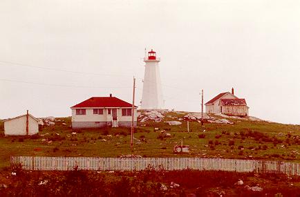
The lighthouse is still being used with an automatic light apparatus
installed, but the houses have been vacant since 1986 when the station became
unmanned. The 1960 replacement tower still stands, along with the houses (all
less than 40 years old), the two sheds (probably the oldest structures on
site), two other badly deteriorated sheds, and a steel tower, once used for a
radio transmitter.
Helicopters are now the main means of Coast Guard transportation to the light station. The road leading to a dock on the other side of the island (about 3 miles away) has not been maintained since the station became unmanned.
Cape Roseway's remaining buildings reinforce the character of the light station primarily by their colours. White with red roofs and doors, they are instantly recognizable as being part of the lighthouse complex, and as buildings owned by the Canadian Coast Guard.
Cape Roseway light station is considered an asset to those promoting tourism in the southern tip of Nova Scotia. Although no longer visible in physical evidence, its long nautical history is inextricably linked to that of nearby Shelburne (population now around 2,000).
ACKNOWLEDGEMENT: Contributors: Chris Mills, Kathy Brown, Bernice
Goodick
Sources: Informal Building Report 87-127, Federal Heritage Buildings Review
Office (FHBRO), April 11th, 1988, "Atlantic Sentinel" The Standard, Jan.
1950, pp 12 - 15, courtesy Bernice Goodick, and a letter from Bernice.
The Lighthouse Today
In the year 2000, the Cape Roseway lightstation sits in an abandoned state. Only the lighthouse remains as an active aid to navigation. The fog horn was taken out of service in 1989. The radio beacon has been discontinued. The dwellings and service sheds have deteriorated badly in the harsh marine environment. Cape Roseway is one of the few stations in Nova Scotia which remains relatively intact. It should be refurbished and maintained as an important example of the large, full-service lightstations once common in Nova Scotia. The dwellings and old fog alarm building are on the Canadian Lighthouse Doomsday List.
ACKNOWLEDGEMENT: Contributors: Chris Mills, Kathy Brown, Bernice
Goodick
Sources: Informal Building Report 87-127, Federal Heritage Buildings Review
Office (FHBRO), April 11th, 1988, "Atlantic Sentinel" The Standard, Jan.
1950, pp 12 - 15, courtesy Bernice Goodick, and a letter from Bernice.
Cape Roseway Lighthouse Locator Map
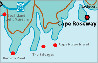 Near the South-East point of McNutt's Island at the entrance to Shelburne
Harbour
Near the South-East point of McNutt's Island at the entrance to Shelburne
Harbour
ACKNOWLEDGEMENT: Contributors: Chris Mills, Kathy Brown, Bernice
Goodick
Sources: Informal Building Report 87-127, Federal Heritage Buildings Review
Office (FHBRO), April 11th, 1988, "Atlantic Sentinel" The Standard, Jan.
1950, pp 12 - 15, courtesy Bernice Goodick, and a letter from Bernice.
CAPE ROSEWAY I - Light Details
- Location: Southeast point of McNutt's Island
- Standing: This light is no longer standing.
- Operating: This light is no longer operating.
- Began: 1787
- Year Lit: 1788
- Structure Type: Octagonal granite tower, black & white stripes, red lantern
- Light Characteristic: Flashing White (1922)
- Tower Height: 077ft feet high.
- Light Height: 120ft feet above water level.
History Items for This Lighthouse
- 1788 - third lighthouse in Canada - 1858 - second light added to tower
- 1883 - catatropic lens, 18m, two fixed white lts - 1884 - fog signal established
- 1915 - fog signal altered - 1922 - 1941 - 3rd order dioptric lens, air diaphone
- 1959 - struck by lightning, fire ensued, replaced by temporary light
CAPE ROSEWAY II - Light Details
- Location: Southeast point of McNutt's Island
- Standing: This light is no longer standing.
- Operating: This light is no longer operating.
- Began: 1959
- Year Lit: 1959
- Structure Type: Light on top of fog signal building, temporary
- Light Characteristic: Flashing white (1959)
- Light Height: 077ft feet above water level.
History Items for This Lighthouse
- 1959 - temporary light replaced original tower while new tower constructed
- 1959 - group flashing white (10s)
- 1961 - replaced by present tower
CAPE ROSEWAY III - Light Details
- Location: Southeast point of McNutt's Island
- Standing: This light is still standing.
- Operating: This light is operational
- Automated: All operating lights in Nova Scotia are automated.
- Date Automated: Automated by 1986
- Began: 1961
- Year Lit: 1961
- Structure Type: Octagonal concrete tower, white, red lantern
- Light Characteristic: Flashing white (1992)
- Tower Height: 048ft feet high.
- Light Height: 111ft feet above water level.
History Items for This Lighthouse
- 1961 - replaced temporary light of 1959
- 1990 - fog signal discontinued, electric lantern
- 1992 - electric lantern, flashing white (10s)
Lightkeepers for Cape Roseway Lighthouse
Head Lightkeepers:
|
Assistant Lightkeepers:
|
Highlights
- County: Shelburne
- Region: South Shore
- Body of Water: Shelburne harbour
- Scenic Drive: Lighthouse Route
- Site Access: By Boat
- Characteristic: Flashing white (1992)
- Tower Height: 048 ft
- Height Above Water: 111 ft
- Latitude: 43~37~21.4
- Longitude: 65~15~50
- Off Shore: Yes
- Still Standing: Yes
- Still Operating: No