Brier Island Lighthouse
Also known locally as: Western Light
Owned by the Municipality of the District of Digby
 The first lighthouse was wooden structure, the first lighthouse on SW coast of Nova Scotia. In 1818 it was described as "so vilely constructed and ill lighted" it was a hazard. By 1832 it had been rebuilt, due inefficiency. This light was an octagonal wood tower with a metal lantern. The building was painted white, with 3 red bands. A large fog signal building also stood on the site. This tower burned in 1944 and was replaced by the current concrete tower.
ACKNOWLEDGEMENT: Contributor: Kathy Brown
Sources: List of Lights 1989, NSLPS database, Sailing Directions
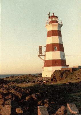
Photo - © Kathy Brown, Brier Island Lighthouse at Sunset c. 1994, Note the electronic fog horn apparatus on the left side of the lighthouse.
Brier Island Lighthouse Locator Map
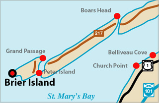 The lighthouse is located on the southwest side of Brier Island just north of Whipple Point. Whipple Point is the SE extreme of Brier Island. From the there, Gull Rocks Bars, most of which dry, extend 1.5 miles SW to Gull Rock, 2 m (7 ft) high. Brier Island Southwest Ledge, at a least depth of 4.1 m (13 ft), is situated 1.9 miles SW of Gull Ledge. A heavy tide rip extends from Gull Rock to about 1.5 miles SSW of the ledge. The lighthouse stands on guard against this hazard. It is accessible by a road across the island.
ACKNOWLEDGEMENT: Contributor: Kathy Brown
Sources: List of Lights 1989, NSLPS database, Sailing Directions
BRIER ISLAND I - Light Details
- Location: West point of island
- Standing: This light is no longer standing.
- Operating: This light is no longer operating.
- Began: 1809
- Year Lit: 1809
- Engineer: Isaiah Shaw
- Structure Type: Wood tower, white
History Items for This Lighthouse
- 1809 - wood lantern, first lighthouse on SW coast of NS
- 1818 - so vilely constructed and ill lighted it was a hazard
- 1832 - had been rebuilt by this date, due inefficiency
BRIER ISLAND II - Light Details
- Location: West point of island
- Standing: This light is no longer standing.
- Operating: This light is no longer operating.
- Began: 1832
- Year Lit: 1832
- Structure Type: Octagonal wood tower, white, 3 red bands
- Light Characteristic: Flashing White (1941)
- Tower Height: 055ft feet high.
- Light Height: 092ft feet above water level.
History Items for This Lighthouse
- 1832 - replaced tower of 1809, metal lantern
- 1873 - fog signal established - 1883 - catatropic light, fixed white, 15m
- 1922 - 1941 - 3rd order dioptric lens, group flashing white (15s), air diaphone
- 1944 - destroyed by fire
BRIER ISLAND III - Light Details
- Location: West point of island
- Standing: This light is still standing.
- Operating: This light is operational
- Automated: All operating lights in Nova Scotia are automated.
- Date Automated: Automated by 1987
- Began: 1944
- Year Lit: 1944
- Structure Type: Octagonal concrete tower, white & red bands
- Light Characteristic: Flashing White (1992)
- Tower Height: 060ft feet high.
- Light Height: 095ft feet above water level.
History Items for This Lighthouse
- 1944 - replaced tower of 1832, destroyed by fire
- 1992 - 4th order dioptric lens, flashing white (18s), fog signal
Lightkeepers for Brier Island Lighthouse
Suthern, John XXX1855XX
Highlights
- County: Digby
- Region: Fundy Shore & Annapolis Valley
- Body of Water: Bay of Fundy
- Scenic Drive: Evangeline Trail
- Site Access: By Car
- Characteristic: Flashing White (1992)
- Tower Height: 060 ft
- Height Above Water: 095 ft
- Latitude: 44~14~55.0
- Longitude: 66~23~32.0
- Off Shore: No
- Still Standing: Yes
- Still Operating: No