Black Rock Lighthouse
View No Ka Oi Drone Video - Horton Bluff & Black Rock Lighthouse/Light
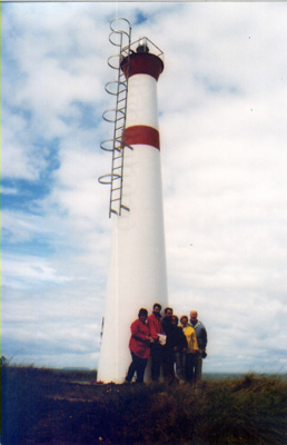 Black Rock Lighthouse, 2002
© Josette d’Entremont
BLACK ROCK I - Light Details
- Location: West of Canada Creek, south shore of Minas Channel
- Standing: This light is no longer standing.
- Operating: This light is no longer operating.
- Began: 1848
- Year Lit: 1848
- Structure Type: Lantern on roof of square wood dwelling, white
- Light Characteristic: Fixed White (1941)
- Tower Height: 035ft feet high.
- Light Height: 045ft feet above water level.
History Items for This Lighthouse
- 1883 - catatropic light, fixed white, 12m, listed as Black Rock Point
- 1922 - 1941 - 4th order dioptric lens
- 1967 - replaced by present fiberglass tower
BLACK ROCK II - Light Details
- Location: West of Canada Creek, south shore of Minas Channel
- Standing: This light is still standing.
- Operating: This light is operational
- Automated: All operating lights in Nova Scotia are automated.
- Date Automated: Automated by 1993
- Began: 1967
- Year Lit: 1967
- Structure Type: Round fiberglass tower, white, two red horizontal bands
- Light Characteristic: Flashing White (1992)
- Tower Height: 034ft feet high.
- Light Height: 049ft feet above water level.
History Items for This Lighthouse
- 1967 - 1973 - replaced original tower of 1848
- 1973 - automated by this date - 1990 - alteration of some form
- 1992 - 4th order dioptric lens, flashing white (12s)
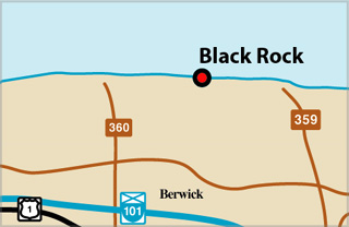
Black Rock Lighthouse Locator Map
Highlights
- County: Kings
- Region: Fundy Shore & Annapolis Valley
- Body of Water: Minas Channel
- Scenic Drive: Evangeline Trail
- Site Access: By Car
- Characteristic: Flashing White (1992)
- Tower Height: 034 ft
- Height Above Water: 049 ft
- Latitude: 45~10~13.2
- Longitude: 64~45~42.6
- Off Shore: No
- Still Standing: Yes
- Still Operating: No