Battery Point Breakwater Lighthouse
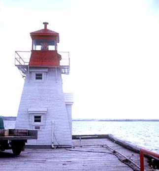 Battery Point breakwater light is shown at an elevation of 22 feet (6.7 m) from a white square tower, on the outer end of the breakwater. A fog signal of one blast every 20 seconds is sounded from Battery Point; the horn points 130'.
ACKNOWLEDGEMENT: Sailing Directions, Nova Scotia (Atlantic Coast) and Bay of Fundy, First Edition, 1990, Dept of Fisheries and Oceans, Ottawa, Canada, Photo - © Courtesy Department of Fisheries and Oceans
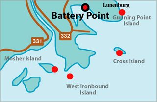
Battery Point Breakwater Lighthouse Map Locator Map
BATTERY POINT I - Light Details
- Location: On point, eastern entrance to Lunenburg Harbour
- Standing: This light is no longer standing.
- Operating: This light is no longer operating.
- Began: 1864
- Year Lit: 1864
- Structure Type: Lantern on roof of dwelling, white
- Light Characteristic: Fixed White (1883)
- Light Height: 050ft feet above water level.
History Items for This Lighthouse
- 1883 - catatropic lens
- 1883 - 1922 - replaced by second tower, maybe new tower built on roof
BATTERY POINT II - Light Details
- Location: On point, eastern entrance to Lunenburg Harbour
- Standing: This light is no longer standing.
- Operating: This light is no longer operating.
- Began: 1937
- Year Lit: 1937
- Structure Type: Square wood tower, white, on dwelling
- Light Characteristic: Fixed Red (1941)
- Tower Height: 024ft feet high.
- Light Height: 081ft feet above water level.
History Items for This Lighthouse
- 1883 - 1922 - replaced original tower of 1864, maybe new tower built on roof
- 1922 - 1941 - 4th order dioptric lens, hand fog horn
- 1930 - listed as square wood building, 24 ft, hand fog horn
- 1944 - 1960 - discontinued between these dates
BATTERY POINT III - Light Details
- Light Type: Breakwater Light
- Location: Outer end of breakwater, east side of Lunenburg
- Standing: This light is still standing.
- Operating: This light is operational
- Automated: All operating lights in Nova Scotia are automated.
- Date Automated: Automated by 1993
- Began: 1951
- Year Lit: 1951
- Structure Type: Tapered square wood tower, white
- Light Characteristic: Fixed Red (1992)
- Light Height: 025ft feet above water level.
History Items for This Lighthouse
- 1937 - mechanical fog bell established
- 1941 - 6th order dioptric lens, fixed red, fog bell
- 1960 - 1965 - fog horn sounded from tower
- 1990 - 1992 - fog horn in operation, electric lantern
Highlights
- County: Lunenburg
- Region: South Shore
- Body of Water: Lunenburg Harbour
- Scenic Drive: Lighthouse Route
- Site Access: Requires Hike
- Characteristic: Fixed Red (1992)
- Tower Height:
- Height Above Water: 025 ft
- Latitude: 44~21~37
- Longitude: 64~17~46.7
- Off Shore: No
- Still Standing: Yes
- Still Operating: No